


Street Maps
| Back to main narrative |
Copies from as many sources as possible are given, since access to them is at best difficult. Most of these maps are "London Underground" style, ie the logical linkage is correct, the actual route of the pipes is ignored, and the positions are adjusted to fit nicely on the paper.
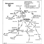
There are discrepancies in the maps in the Leopoldstadt area, ie along Taborstrasse towards the Prater. The 1900 and 1903 maps have W2 Fleischmarkt connected to W36 Produktenbörse, then a gap, then W34 Stefaniestrasse connected to W23 Taborstrasse, W27 Czerninplatz, W28 Nordbahnhof and so onwards. However the 1907 and 1913 maps show W2-W34-W36-W23 etc.
Looking at the 1875 map, one can see that the original pipe ran under Ferdinandsbrucke (now Schwedenbrucke) on its way to the Leopoldstadt office at Taborstrasse 27 (see the 1875 map); this office became W23. W36 was the new Produktenbörse, at Taborstrasse 10. And W34 was Stephaniestrasse, located at "Stephaniestrasse 1, Obere Donaustrasse 83" which presumably is on the corner. A modern street map shows that Ferdinandsbrucke is now Schwedenbrucke; Stephaniestrasse is Holland Strasse; and the corner is Friedrich Wilhelm Raffeisen Platz. It is possible to speculate on the route the pipe might have taken, remembering that it ran from office to office to office and initially did not have spurs. Unfortunately W2-W36-W34-W23 and W2-W34-W36-W23 are both plausible.
However, consider the last page of Post- usw Dienst im Lokalpost-Rayon von Wien: Feb 1892. The first part of that table is the timetable for the Taborstrasse radial pipe. This is early 1892, so W23, W34, W36 are all open. The routing is evidently W2-W36-W34-W23. It is we concede possible that when the radial stretch to Taborstrasse was extended to become the circular route via Nord- and Nordwestbahnhof the piping was changed round – no timetables have been found for these later dates.
'Click the Pic' to open a new window with a larger version of the picture; you may need to use the slidy-bars to see all of it; close it when done-with.
| Map | Date | Details | Comments |
|
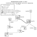
1875 | "Pneumatischer Telegraph In Wien", dated 1875. | This was found by Fluck in the Post and Telegraphen Museum, Wien. Taken from "K. k. Telegraphen Central Station, Wien 1874" written by Georg Ehlich, an official of the k. k. Telegraphenamt, and issued on 1 March 1875. See here for a copy! On this illustration, the pipe routes have been highlighted in red, and the offices in blue. The extremely large original is here, with a mini version inset at top left; a a smaller version is here |
|
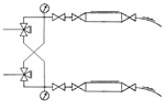
1875 | The "Fusebox diagram". | This is from Ehlich's book, page II, and is a schematic plumbing diagram of the connections and valves in the original system. |
|
1875 | The "plumbing diagram". | This is redrawn from Ehlich's book; it shows the detail of an intermediate station such as Wieden. Note the 3-way valve arrangements, and the removable lids through which the Büchsen were removed from the large cylindrical section, or inserted into the downwards-sloping pipe. |
|
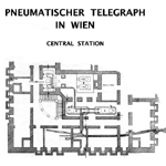
1875 | Ehlich page III | Plan and cross-sections of the pneumatic installation in the Central Telegraph Building |
|
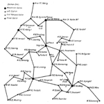
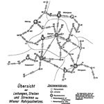
1900 | From Klein vol 2 page 715 (APS Lib item 31B). | There are two errors in his book, corrected here: W34 Stefaniestrasse and W36 Productenbörse were connected together (this is also evident from the 1892 timetable); so were W7 Effectenbörse and Telegr. Zentrale. The map is described as being taken from the following map and modified to show the state as at 30 September 1900. [It is also reproduced, unreadably, in No. 372/373 of "Die Postmarke", dated 3/12/1936, pages 287 to 291.] |
|
1903? | From "Wien am Anfang des XX. Jahrhunderts" vol 1 p 153. | This book, published in Vienna in 1905 by Ing. Paul Kortz, has the errors that Klein carefully copied! |
|
1907 | Ultimately from the 1907 Festschrift on "Die K K Telegraphenzentrale in Wien". | From "500 Jahre europäische Postverbindung" page 76 and "Österreichs Post: vom Botenposten zum Postboten" page 116; both reproduce the plan on page 12 of Turner's "Die Stadtrohrpost in Wien" dated 1978 [Technical Museum Library ref B6983] which in turn says it was copied from the 1907 Festschrift on "Die K K Telegraphenzentrale in Wien". |
|
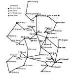
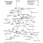
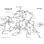
1875-1912 | Network map showing opening dates etc. | Note that in these network maps, which are all produced by the Pneumatic Post Engineering Department, Nord-West-Bahnhof is shown as station 20; all other documents refer to it as 24. |
|
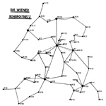
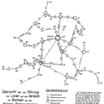
1913? | Hajek, allegedly taken from the next map | Appendix 1 of "Geschichte der Wiener Rorhpost" by Dr Hajek; "taken from Rohrpost Fernanlagen by Dr Ing Schwaighofer pub.1916". It shows "the system at its maximum extent ie in 1913". There are some changes from the claimed original! |
|
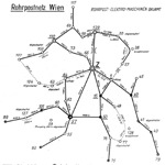
1913? | From "Rohrpost Fernanlagen". | From p.322 of "Rohrpost Fernanlagen" by Dr Ing Schwaighofer. Map undated; book published 1916. There is a typo: "W56 Porzellangasse" should be W66. |
|
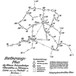
1924? | "Stand vor dem 1. Weltkrieg". | Although this is inscribed in pencil "Stand vor dem 1. Weltkrieg (State as before WWI)", the opening & closing dates of the offices shown and also those omitted suggest that it must be after 1922 and is probably 1924. The extremely large original is here; a a smaller version is here. |
|
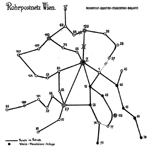
1932 | Appendix 1 of "10. Dienstanweisung" part II. | Shows also the sources of pressure and vacuum for each station. |
|
1932 | Appendix 2 of ditto | Shows also the 'through' and 'stopping' routes for each station |
|
1945 | Immediately post-WWII network map, showing working sections | |
|
1946 | Post-WWII network map, showing working sections | From "500 Jahre europäische Postverbindung" page 76 and "Österreichs Post: vom Botenposten zum Postboten" page 116; both of these reproduce the plan on page 13 of Turner's "Die Stadtrohrpost in Wien" dated 1978 which says it was copied from an unstated source. |
|
1956 | From Turner's "Die Stadtrohrpost in Wien" page 13. | Turner has a detailed diagram (attributed to Strasser, 1955) with each pipe labelled with the streets under which it ran; it also shows several of the out-of-commission sections. The map also exists in the Strasser original. |
|
1956 | The slightly different Strasser diagram (Turner page 14) with each pipe labelled with the streets under which it ran. There are two versions of this diagram, both large. The first seems to be the working drawing of the Rohrpost-Elektro-Maschinen-Bauamt; it has slightly more details and the lettering was done with a fine pen. The second seems to be a redrawn version of the first to form "Bild 3" of Turner's book; the lettering is bigger and blacker. For both, a minified version has been added at the top left, to give an idea of what's there when the link is clicked. | |
Street Maps | |||
|
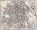
1891 | 1891 Vienna street map, smaller version | |
| 1891 Vienna street map, 4x larger version | |||
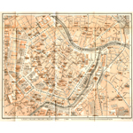
|
1891 | 1891 Vienna street map, inner city, smaller version | |
| 1891 Vienna street map, inner city, 4x larger version | |||
|
1911 | 1911 Vienna city street map, smaller version | |
| 1911 Vienna city street map, 4x larger version. NB: big file, may load slowly! | |||
|
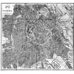
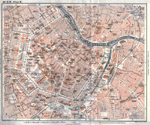
1911 | 1911 Vienna inner street map, inner city, smaller version | |
| 1911 Vienna inner street map, inner city, 4x larger version. NB: big file, may load slowly! | |||
| Back to main narrative |