| Back to main narrative |
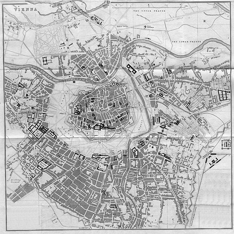
Vienna in 1850 consisted of the old city surrounded and hemmed in by fortifications and a military glacis, which separated it from a surrounding and ever-expanding fringe of suburbs (and vineyards!). This is shown clearly on a map of 1858 (found on the Internet). Note what became the Danube Canal above the city, the open Wiener Fluss (Vienna River), the channels of the Danube at the top, and the jagged line of the outer fortification walls (Linienwälle) which are today's Gürtel. The street heading to the bottom right is Wiedner Haupstrasse. The large dark building at the 'bottom' of the inner city is the Hofburg; directly facing it through the Burgtor and across the glacis are the Imperial Stables, now the Museum-Quarter. The top of the map points roughly north-east.
Compare the 1858 map with a modern satellite photo (below; also from the Internet) which has been rotated to match. At the top is the Danube; below it the "star" of roads radiating from the Praterstern, Wien Nord station, with Lassalle Strasse going straight up and crossing the Reichsbrücke. The Danube Canal meanders across the middle; the outline of the old city walls has been superimposed in red; the parallel streets surrounding it are the Ring; the route of the Wien river through the Stadtpark is shown in ochre. Part of the Gürtel, which follows the line of the old Linienwälle, runs from Westbahnhof at the bottom towards the left, passing the Allgemeines Krankenhaus which is next to the Volksoper.

From 1850, Vienna began to expand, by incorporation of the suburbs and especially by demolition of the old defences - the revolutionary events of 1848 convinced the authorities that it was more important to allow the Imperial Army free access to the citizens of the inner city than to keep the Turks out of it! The post-1848 constitutional changes enabled the City to prevail over the suburban landlords. A further drive to incorporation of the suburbs was the rapidly rising population and increasing squalor; housing was entirely privately owned and the suburbs had insufficient revenue to deal with their inadequacies. Tuberculosis became internationally known as "Vienna disease".
This expansion had considerable philatelic consequences, as Post Offices were opened, closed, and renamed; Bezirke (districts) created, changed, and abolished; and streets in the new Bezirk assigned a new name if their old name already existed within the city. For example, a pneumatic office was opened in 1880 at Schönbrunnerstrasse 42 in the independent town of Fünfhaus; in 1890 that street became Äussere Mariahilferstraße, Wien XV; in 1893, pneumatic service from that office ceased.
In "A History of the Habsburg Empire 1700-1918" by Jean Bérenger, page 226, one reads: By the Imperial Rescript of 25 December 1857, the emperor ordered the demolition of the old bastions encircling the capital. ... Until Francis Joseph's intervention, the town proper had been separated from the suburbs by a featureless expanse of ground which was used by the regiments in the garrison for manoeuvres ... The decision to undertake the project was reached after long discussions and was generally well-received. Work began immediately and after two months the first bastions were blown up. On 31 December 1858, the plans for rebuilding, the work of the architects Siccarsburg, Van der Null and Förster, were published ... the latter ... had the idea of putting the Ringstrasse in the middle of the old glacis. ... The imperial administration [sold] the vast expanses of ground to capitalists who then built apartment blocks. The treasury received from this venture 220 million florins which was then spent on public buildings".
Yet another from-the-internet map shows the plan; it is about 45º clockwise to the previous one. Note the large open area to the left: this was retained for military exercises for many years, until released for the construction of the Town Hall. The Linienwalle show up well!

The Opera House was the first, opening in 1869; Town Hall (built 1872-83); Stock Exchange (1877); Parliament (1874-83); Burgtheatre (1888). At the same time the Wiener Fluß was partly canalised, and a few streets reassigned to a Bezirk on their own side of the new channel. The boundary of Bezirk 1 was, and remained, in the middle of the western glacis, the outside of the southern glacis, and up the centre of the Wiener Fluß - eg it runs up the middle of Maria-Theresien-Straße, not Schottenring.
On 6 March 1850, Vienna expanded by incorporating the habitations between the city walls and the Linienwalle, creating Bezirke 2-8. On 5 Oct 1861 a new Bezirk 5 was carved out of Bezirk 4; 6-8 became 7-9. Later, the Bezirke were given names:
|
1 |
Innere Stadt |
2 |
Leopoldstadt |
3 |
Landstraße |
|
4 |
Wieden |
5 |
Margarethen |
6 |
Mariahilf |
|
7 |
Neubau |
8 |
Josefstadt |
9 |
Alsergrund |
Between 1869 and 1875, the Danube was regulated, turning the area between today's Danube Canal and Floridsdorf from a swampy area of silting & changing braided channels into the main River (where the commercial shipping was) and the Canal. This increased the economic (and therefore the philatelic) importance of the Brigittenau & Prater areas, which were added to Bezirk 2.
On 22 April 1874, Favoriten became Bezirk 10.
On 19 Dec 1890 the second major expansion took place, adding Bezirke 11-19. Vienna's post offices were renumbered in 1892, so for example Fünfhaus became Wien 100.
|
11 |
Simmering |
12 |
Meidling |
13 |
Hietzing |
|
14 |
Rudolsheim |
15 |
Fünfhaus |
16 |
Ottakring |
|
17 |
Hernals |
18 |
Währing |
19 |
Döbling |
On 24 Mar 1900 Brigittenau was separated from Bezirk 2, becoming Bezirk 20.
On 28 Dec 1904, Vienna incorporated the towns around Floridsdorf, to the north of the Danube, as Bezirk 21, adding Strebersdorf to it in 1910.
With the Anschluß, the so-called Grosswien was created: on 15 October 1938 Bezirke 22-26 (comprising 97 communities) were added and several Bezirk boundaries changed.
|
22 |
Groß Enzersdorf |
23 |
Schwechat |
24 |
Mödling |
|
25 |
Liesing |
26 |
Klosterneuburg |
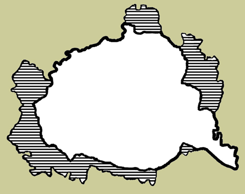
This shows in outline the WWII expansion of Vienna into Grosswien. For fuller details, see Stohl Part A1 and Kruger. The creation of Grosswien was formally reversed by the Austrian Government on 29 June 1946 when they passed the "Territorial Review Act" (Gebietsänderungsgesetz). However no actual change took place until 1 Sep 1954 when the Occupying Powers, especially the Russians, withdrew their objections.
Until then, those districts which had existed before 1938 were divided into four Allied zones, and the inner-city district was administered by all four powers as the so-called "Inter-allied Zone". Districts 22-26, namely the 97 Lower Austrian communities which had been merged with Vienna in October 1938, came under Soviet control as part of Lower Austria [the trade-off being that the Western Allies obtained better access to the airfields around Vienna]. When the State Treaty was eventually signed, Niederösterreich took back Schwechat, Mödling and Klosterneuburg. Liesing became Bezirk 23, and several boundaries were changed. Further small boundary adjustments were made in 1956 & 1957. In 1972 further regulation of the Danube created the Danube Island, on which the politically and philatelically independent U.N. Centre was built.
This map shows the expansions; the Bezirke boundaries and numbers are shown, taken from a 2000 map. The Anschlüß period has been ignored.


| Back to main narrative |